New Publication: Exploring Roman Frontier Mobility with GIS and Network Analysis
More On Article
- Faces reveal accurate information about overhand throwing ability in men.
- First Austrian-led expedition presents finds from the "Cradle of Humankind"
- Where Physics, Chemistry and Archaeology Meet: Applications and Case Studies in (p)XRF
- Tiny Hopes─Assessing Protein Preservation in Collagen-Depleted Bones.
- It Takes Two to Tango: A Pluralist Account for Building Comprehensive Explanations in Human Evolution
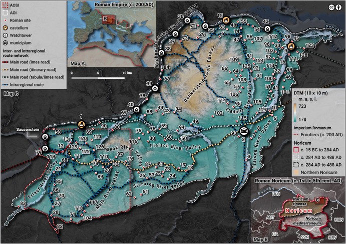
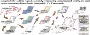
We are pleased to announce the publication of the new research article “I Walk an Ancient Road: A Straightforward Methodology for Analyzing Intra- and Inter-Regional Connectivity Systems along Roman Frontier Zones (c. 1st–5th century AD)” by Dominik Hagmann in the Journal of Archaeological Science:
This study presents an innovative methodology for reconstructing ancient road networks in Roman hinterlands, focusing on the Danube Limes in Northern Noricum (modern Austria). By integrating Geographic Information Systems (GIS), Least-Cost Analysis (LCA), Spatial Social Network Analysis (SSNA), and Visibility Analysis (VA), the research uncovers patterns of movement and connectivity between military, economic, and civilian sites along the Roman frontier.
Key findings include:
- A detailed reconstruction of potential Roman roads and transportation networks in the hinterland of the Danube frontier.
- Insights into how military logistics, trade, and settlement patterns were influenced by infrastructure.
- Methodological advancements for applying digital archaeology, computational modeling, and open data in Roman studies.
This approach enhances our understanding of mobility in ancient borderlands and offers a scalable method for future research on historical transportation networks. For more details, read the full article here: https://doi.org/10.1016/j.jas.2024.106151